- Places
- Plans
- Itineraries
- Experiences
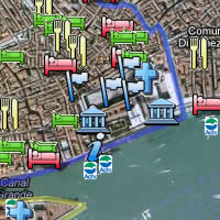
For full information on arriving in Venice by boat, click here. The below is just a blown-up map showing the layout of the various cruise terminals, ferry docks, access roads, etc.
Since the terminal numbers don't mean much to us tourists, here's the real key:

A map of the Stazione Marittima and San Basilio cruise terminals, ferry docks, and public piers.
Stazione Marittima Venezia
Piazzale Tronchetto
Alilaguna ferry: B (seasonal)
Vaporetto: Staz. Marittima or S. Basilio
tel. +39-041-240-3000
www.vtp.it
Share this page
Search ReidsItaly.com

This article was written by Reid Bramblett and was last updated in April 2015
.
All information was accurate at the time.
about | contact | faq
» THE REIDSITALY.COM DIFFERENCE «
åß
Copyright © 2008–2017 by Reid Bramblett. Author: Reid Bramblett